Processes in continental shelf systems Shelfs are shallow-water areas which represent a belt along the continents like a bridge between land and the open ocean. Their distal part, the shelf break, is commonly located at around 150 m water depth. Their ecosystem is the richest and most productive area of the world's ocean and, therefore, of high economical (fisheries) and ecological importance. Most parts of a shelf are very shallow and the seafloor is, consequently, frequently affected by wave, tidal, storm, and current activities. Large amounts of clastic and organic material is provided by the hinterland and then distributed, sorted, deposited and often again reworked in the sedimentary shelf system. In this way, shelves act as filters of the sparse material which reaches the deep ocean finally. Shelf settings also control the stability of coastlines. Finally due to the shallow water depth, shelves are especially sensitive to changes in sea level and major parts become exposed as soon as sea level sinks what happened frequently in the past.
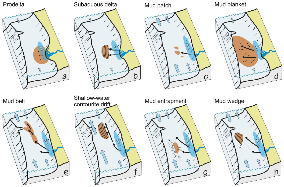
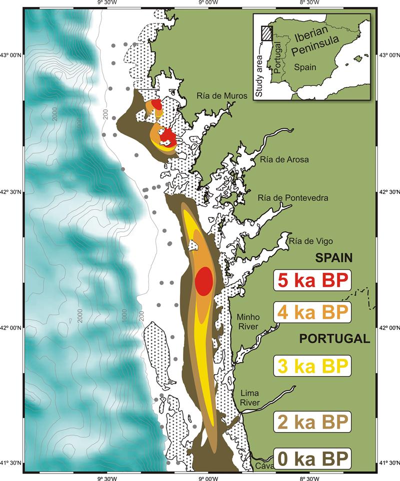
Mud depocentre evolution dynamics The deposition of sediments is a complex and dynamic process due to a variety of controlling factors such as position of the sea level, tectonic setting, morphology of the sea floor, sediment supply, and hydrodynamic regime. Although some general patterns are known, for instance, the reworking of sediments and landward shift of facies belts during deglacial sea-level rise, the specific formation of larger depocentres remains largely unknown and, therefore, oversimplified. Members of our working group were able to reconstruct for the first time the detailed evolution of a mid-shelf mud depocentres. The investigations show that such depocentres do not necessarily expand linear from the source of terrigenous supply (Lantzsch et al., 2009). In contrast, they may have initially started to form in a confined centre detached from the sediment source due to the wave regime and expanded afterwards into specific directions. These observed dynamics could be a general mechanism for the development of, for instance, mid-shelf mud depocentres and the results draw attention to this previously unobserved field. Thus, the investigations improve our understanding of the particular controls on the sediment distribution.
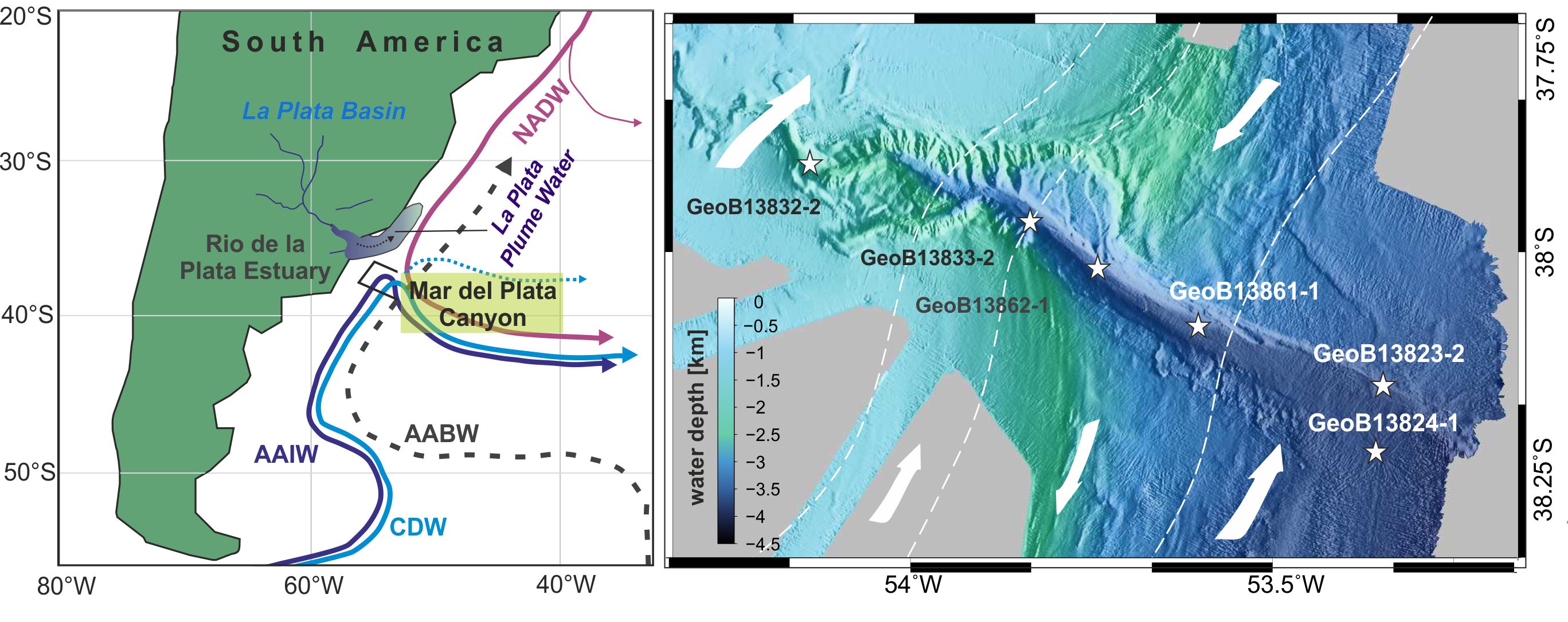
Mid-slope canyon sedimentation There is a general lack of understanding as how submarine canyons are major player shaping continental margin and guiding sediment transport from the shallow to deep water marine systems. Decoding the interaction between contour currents and canyon deposition especially requires more integrated research if canyon floor sediments are to be used as a paleoceanographic archive.
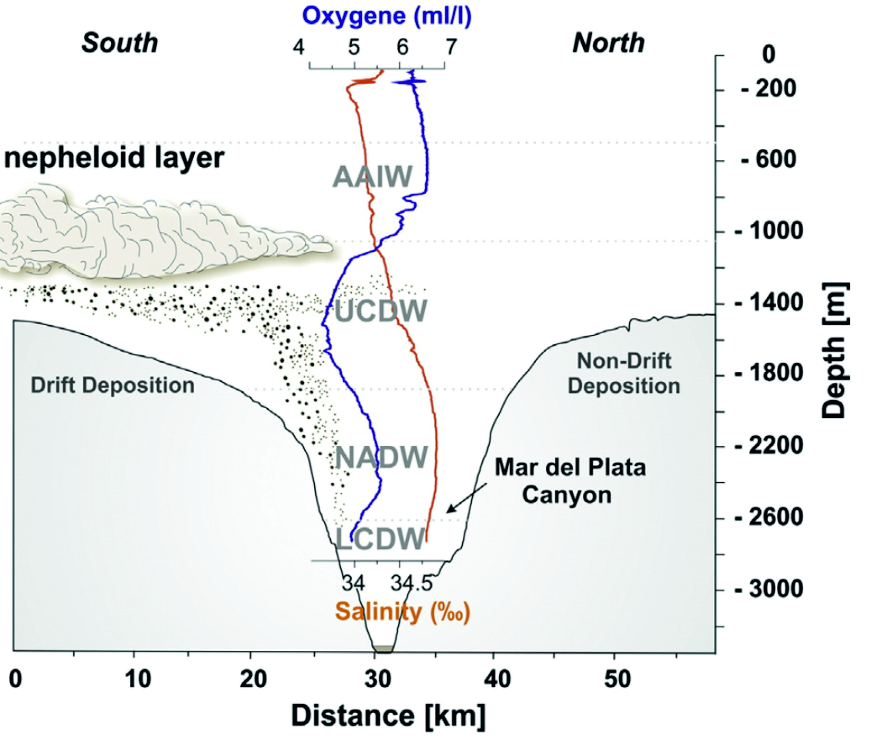
The Mar del Plata Canyon (SW-Atlantic, offshore Argentina/Uruguay, 38°S) is well suited, since the canyon head is situated at a mid-slope position. Its downslope track crosses all intermediate and deep water masses shaping the continental slope off Argentina. Despite its location close to the mouth of the La Plata River, the canyon has no direct connection to the shelf or to the La Plata River. During the last 20 ka the sediments in the canyon came more likely from the adjacent Ewing and Necochea Terrace. Thus the sedimentary record of several gravity cores, taken during the RV Meteor Cruise M78/3 inside the canyon, give further evidence into the discussion of glacial versus interglacial intermediate and deep water mass circulation as well as a new insight in along- and down-slope sedimentation processes in a mid-slope canyon.
Canyons and climate (South America) The Mar del Plata Canyon is located at the continental margin off Argentina, whose overall architectural evolution is mainly controlled by the intermediate and deep-water global conveyor belt. The canyon is incorporated into a significant contourite depositional system (CDS) and is affected by both, down-slope and along-slope transport and sedimentation processes. Sediment cores from the thalweg of the canyon show unusual high accumulation rates up to 100cm/kyr during the Holocene. Presumably the canyon interacts with the deepwater circulation and the sediment material is mainly derived from contourites and related deposits. Moreover, in the same sediment cores intercalation of (cyclic) fine-grained turbidites reveal climate controlled shifts in the sediment supply during the Holocene and could be related to changes of the erosion/weathering regime in the hinterland. Therefore, the Mar del Plata canyon allows to evaluate the sedimentary imprints of the interplay between gravity-driven and current-driven transport mechanism and to decipher the dominant processes in relation to climate changes. This information can be used to improve the basic understanding of submarine canyons as a sink in the interplay of paleoclimate and/or paleoceanographic variations.
Canyons and climate (NW Africa) Exciting insights were extracted by comparing the evolution of sediment dynamics within and around large canyons. Comparative studies of sediment cores from the Timiris Canyon located offshore Mauritania with hyperarid core region of the Sahara in the hinterland (Henrich et al. 2010) and the Dakar Canyon at the margin off Senegal indicate that turbidity currents attained highest frequencies and largest volumes during the glacial sea level lowstands in both systems. 23 of these high-volume turbidite events have flown through the Timiris Canyon, in the distal sector still spilling over its 90 metre elevated levees before being spreading out onto the abyssal plain. Analysis of the entrained material in these turbidites displays a mixture of dust, dune sand and organic matter derived from high productivity upwelling areas at the shelf margin and uppermost slope (Henrich et al. 2010). Already known was that the climate around the Sahara during the last glacial maximum was much drier compared to today, and that the export of dust to the ocean was considerably increased. Our recent studies proof now that one consequence of these drastic changes in glacial sedimentary regimes was a significant enhancement of turbidite activity in canyons draining the surrounding African margin. Turbidite frequency remained high in both canyons during deglacial sea level rise displaying a persistent discharge of sediments from the uppermost slope and outermost shelf through canyons and its final dispersal onto the abyssal plain. Contemporaneous with the shift into more humid Holocene climates the turbidite records of both canyons changed considerably. In the Dakar Canyon turbidite activity dies out completely, because of a significant reduction in sediment supply induced by a sharp decline in dust export and erosion of soils by a growing semiarid vegetation cover (Pierau et al. 2010), whereas turbidites are observed throughout the Holocene in the Timiris Canyon (Henrich et al. 2010). However, these turbidites attained significantly lower volumes compared with the deglacial events, and thus already thinned out in the upper part of the Timiris Canyon system never reaching the deep sea again. Remarkable is a rather constant 900 years recurrence pattern of the turbidite events (ZĂĽhlsdorff et al. 2008). In addition, our recent studies show that during the past 5000 years increased dust supply onto the shelf appears to occur almost contemporaneously with the observed regular periodicity of turbidite events in the Upper Timiris Canyon (Hanebuth and Henrich 2009). The explanation of this temporal coincidence is as follows: During every 900 year recurrent, severe, only for few decades lasting droughts extraordinary strong dust storms delivered huge amounts of dust onto the shelf and upper continental slope. Thick dust layers accumulated on the outer shelf and upper slope also being entrained and filling up the numerous gullies at the head of the Timiris Canyon, where in short time overcritical pore pressures developed and thus the turbidites were released. In conclusion, the most significant new result of our synoptic studies is the not jet recognised strong causality between changes in climate induced sediment delivery to continental margins inducing shifts in sediment dynamics around canyons and triggering turbidite activity. Beside sea level changes this mechanism provides an important control for the frequency and volumes of turbidites in submarine canyons.
Mass wasting on continental slopes During joint research cruises with colleagues from the geophysics and geochemistry departments in 2003 and 2005 mass wasting processes on the NW- African margin offshore Mauritania and Senegal were investigated. The most important outcome of these cruises was the new discovery of a large canyon system draining the margin off the hyperarid core region of the Sahara desert, which is the Timiris Canyon.(Krastel et al. 2004). In addition, several other canyon were mapped and sampled amongst which the largest is the Dakar Canyon located off the Sahelian climate belt and thus being influenced both by fluvial discharge and dust supply as well. Beside these canyons distinct regions of the studied margins are characterised by slumping and sliding of sediments. New results concerning these large scale mass wasting processes were derived for the Mauritania Slide Complex. Seismic surveys displayed typical retrogressive features for this slide, e.g. a stack of upslope back stepping huge slides and slump packages. The topmost units are debrites dated at 10.6 ka comprising the youngest mass wasting events in this region (Henrich et al. 2008). Recently in a joint study with colleagues from the geotechnical working group of MARUM the evolution of youngest mass wasting processes were reconstructed in much more detail. In particular, it was shown based on the results from density and shear stress measurements that the uppermost layered debrite unit comprises a stack of at least two debrite events, which were released from different segments of the continental slope (Förster et al. 2010).